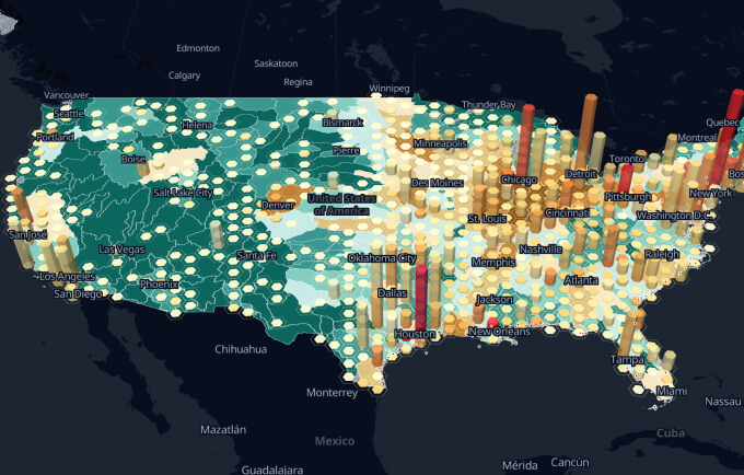
Interactive maps can be used to show the geographic locations of sales offices, display photos on a floor plan, show location or property maps, or add diagrams or illustrations with more detailed explanations.
Hotspots
An interactive map can have hotspots, which are locations on an image or map that you can scroll or click to display additional location information or a link to other web pages. For example, a map of a shopping center can come to life with pop-up windows that show a photo of the storefront, information about the products that are for sale in the store, a phone number, a website, and more.
Educate
They’re great for visiting museums or college campuses, both online and at on-site kiosks. They can help educate students of all ages about geography and encouraging the exploration of countries, regions, communities, and cities.
Advanced features
We’ve all seen maps of the world that ask us to click on a country or maps of a country that ask us to click on a state for more information. But newer generations of interactive map software offer more advanced features. Previously, you had to be a web programmer for the map to be interactive. With the new interactive map software, creating maps is easier than ever.
Other use cases for interactive maps include complex or technical machine diagrams that can show what each part does, physical or electrical specifications, or other technical data aimed at a target audience. Some companies use interactive diagrams to help customers locate parts – the user can hover over a part in the diagram and find its part number, cost, stock availability, and even click to buy.
Customize
The mapping software allows users to include only the information they want customers to see, as well as easily customize the color theme, background, and level of detail to display. Pre-designed map templates will also allow non-technical users to add photos or illustrations as backgrounds for interactive cards. If you have a specific image, such as a JPG image from a digital camera, you can place it in the background to enhance the attractiveness of the card.
Free trial
Creating maps is now easy and users can choose from a variety of commercially available software or web services. Most programs offer a free trial to help you take an evaluation and make a decision. Prices for the software can be found on the websites. But cost shouldn’t be the only factor as quality is the most important thing unless you are a technical user trying to create a map yourself.
Box templates
Out-of-the-box templates at Show map allow users of all skill levels to easily navigate their way, such as using icons to identify locations and using lines and arrows to show routes or indicate points of interest. Users can also choose from a variety of color themes and font settings to create a personalized interactive flashcard to suit their needs and the style of the existing website. Once the map has been created, users can easily integrate it using the software’s web publishing feature, which typically provides several options, including publishing as a flashcard (with an interactive feature) or as a static image so that you can embed the map into your text document or PowerPoint presentations.
Attract visitors
People who create websites don’t always think, “I need a map on my website.” But adding an interactive image or “map” to a web page can attract visitors and keep them on your site for longer. Interactive maps can help people understand business products and services make them more understandable and desirable.

Worthview Editorial Team is the shared byline for content created collaboratively by Worthview’s editors and contributors. Since 2008, we’ve published thousands of articles across technology, AI, finance, health, home, travel, and lifestyle. Our editorial process emphasizes original research, reputable sources, regular content updates, and clear attribution. Articles covering higher-trust topics, including health and finance, may also undergo review by qualified subject-matter experts.